Brunswick – New Hanover
Pedestrian Connection
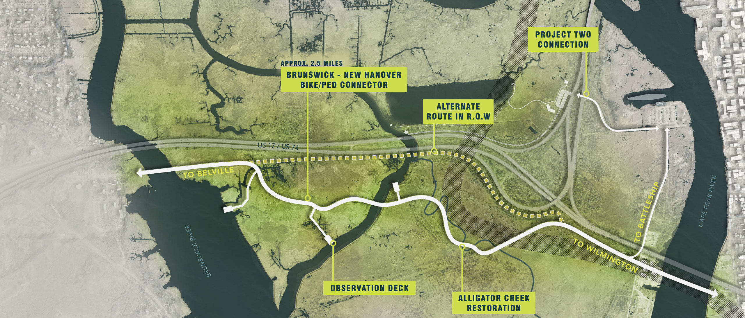
Pedestrian access and community connectivity is a top priority of the Eagles Island Nature Park vision. Establishing an off-road pedestrian route across Eagles Island will provide immersive access to the island from the nearest population centers on both sides of the rivers. Since access opportunities are limited elsewhere on the island, site interpretation and educational goals can be integrated along this route. Additional walking trails or boardwalks and amenities such as observational decks or towers can also be expanded from this route, where appropriate.
The Eagles Island connection between Belville and neighboring Brunswick County communities with downtown Wilmington also serves as the missing link of an extensive multi-county park system with connections to regional and national recreational networks. The proposed route would establish a physical connection with the USS North Carolina Battleship that is mutually beneficial to the mission and visitorship of both the Battleship and Nature Park. Furthermore, the Eagles Island connection would link with the planned Alligator Creek Restoration project and associated nature trail. This route is identified in the Belville 2030 Vision Plan as connecting to an expanded Brunswick Riverwalk and is also a critical segment of the proposed Gullah Geechee Cultural Heritage Corridor Multi-Use Greenway/Blueway Trail, a multi-modal pedestrian network that connects to the East Coast Greenway in Southport and Wilmington.
This project heavily relies on extensive infrastructure improvements including the establishment of a new pedestrian bridge across the Brunswick River or improvements to the existing vehicular bridge to accommodate pedestrian use. Access across the Cape Fear would require construction of the Cape Fear Memorial Bridge replacement to include bike and pedestrian accommodations. Ideally, a dedicated bike and pedestrian route would be established, but a pedestrian ferry service between Wilmington and Eagles Island could also facilitate easy public access. These projects come with a lengthy timeline, but fundraising, planning, and design development of sections of the Eagles Island route can begin immediately. With NCDOT coordination, the majority of the route could be located within the US 17/US 74 and Battleship Road rights-of-way. However, the pedestrian experience would be significantly enhanced by routing the greenway away from the busy highway corridor. The preferred route would require establishing partnerships and shared-use agreements with the North Carolina Ports Authority and the US Army Corps of Engineers who manage the land south of the highways.


