Education Center
Establishing an educational center has remained essential to the Eagles Island Nature Park vision throughout the evolution of Eagles Island preservation efforts, and would complement the Battleship Memorial’s popular educational programming. While this type of facility would undoubtedly provide an exceptional local and regional amenity, development opportunities are limited due to the island’s sensitive environmental conditions, wetland soils, and persistent flood risk. The only location in the study area suitable for development lies within several privately owned parcels south of the USS North Carolina Battleship. This area has been extensively modified over time, contains predominantly urban/modified soils, and is the highest elevation on the island. Importantly, the surrounding soils are all wetland soil types. While elevation across most of the island ranges from 0-10 feet above sea level, the high point in this area has an elevation approximately 15 feet above sea level and is one of the few shoreline areas that will not be inundated by a 10-year flood event (10% probability of annual occurrence). Given the lower environmental impact, reduced flood risk, and proximity to existing infrastructure, this high ground (approximately four acres) is the most suitable location for an educational center on the island. This location also provides the best access to the section of Eagles Island shoreline that contains
dozens of sunken vessels. These artifacts present a unique opportunity to establish a boardwalk and interpretive material for an immersive experience highlighting shipbuilding and maritime history while preserving state-recognized historic artifacts. Because this area is privately owned, initiating conversations with the current landowner to gauge interest in the potential sale or lease of the land, lease of future building space, and/or partnership to develop mutually beneficial programming is recommended. If development of an educational center at this site is feasible, the diagram above illustrates various building sizes, their potential programs, and the required parking areas for each.
An additional consideration for development is that much of the land in this area is registered as a brownfield site with the North Carolina Department of Environmental Quality due to environmental contamination. Initial remediation efforts have been undertaken, but additional remediation activities may be required. Based on the type of contamination, NCDEQ has restricted use on these parcels to single-family residential, high density residential, short-term rental home, office, retail, restaurant, hotel, recreation, marina, open space, and associated parking.
Immersive Site Interpretation
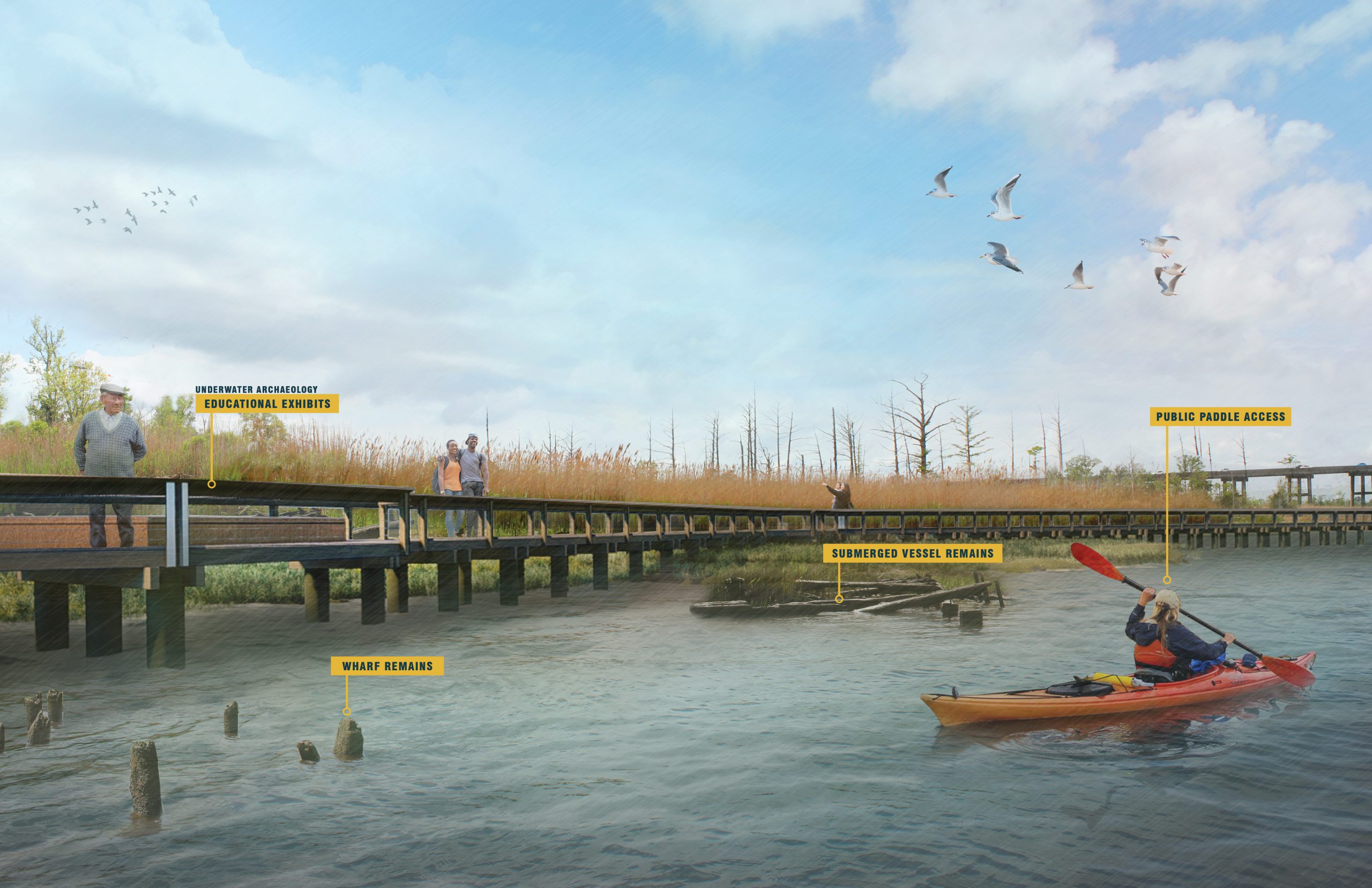
Boardwalks along the eastern shore of Eagles Island enable visitors to interact with the Cape Fear River’s many sunken vessels and provide an opportunity to learn about local maritime history and shipbuilding.
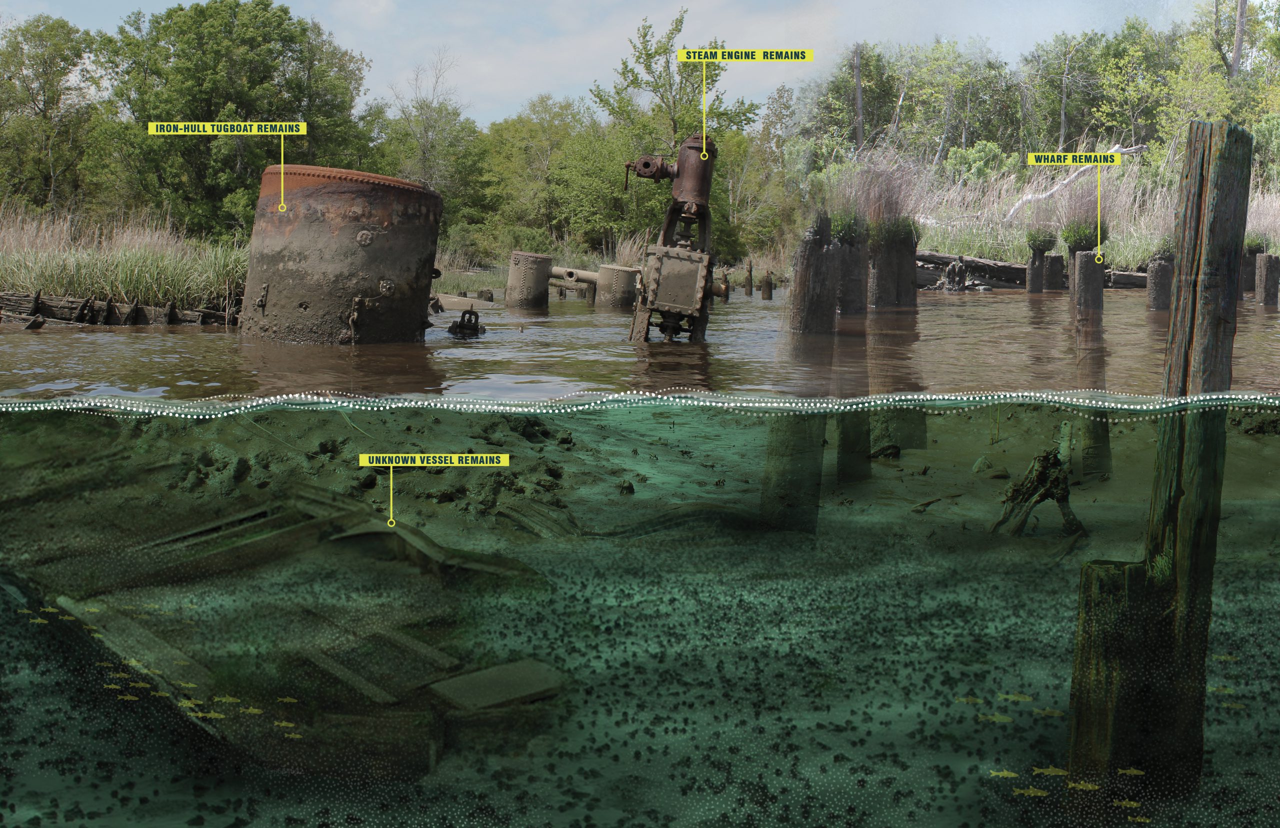
Underwater Archaeology
The shoreline along Eagles Island, just opposite downtown Wilmington is a ships’ graveyard containing more than 30 submerged boats, barges, and other watercraft. Many of the vessel remains are visible at low tide.

Visitors Center
An educational center and riverfront park area welcomes visitors to Eagles Island Nature Park and can host many interpretative and information exhibits most pertinent to the island and the broader Cape Fear Region.

Research and Education
Eagles Island Nature Park will collaborate with local universities, schools, and other groups interested in the island’s cultural and maritime history, as well as the impact of human intervention and climate change on the landscape.
