This 1914 panoramic image of Eagles Island was taken from the top of the Murchison Building and is courtesy of the New Hanover County Library. It is hanging above the door to the North Carolina Room at the downtown library.
Explore the Lost Waterfront of Eagles Island
Stretching across the Cape Fear River opposite downtown Wilmington, this remarkable panoramic photograph captures the industrial shoreline of Eagles Island as it appeared around 1914–1915. During the early twentieth century, this waterfront was home to shipyards, marine railways, lumber mills, naval stores companies, warehouses, ferry landings, and other industries that helped make Wilmington one of the South’s busiest ports.
The original panoramic photograph is preserved in the North Carolina Room of the New Hanover County Public Library in downtown Wilmington. The library graciously provided Eagles Island Nature Park with high-resolution digital copies of the panorama, making it possible to restore the century-old image and study details that are difficult to see in the original photograph. Evidence suggests that the panorama was produced by the Haines Photo Company of Conneaut, Ohio, one of America’s leading panoramic photography firms during the early twentieth century.
The panorama has been digitally restored and carefully compared with Plate 48 of the 1915 Sanborn Fire Insurance Map of Wilmington, reproduced below. Beginning in the 1860s, the Sanborn Map Company created detailed maps for fire insurance underwriters, documenting individual buildings, their construction materials, industrial uses, railroads, docks, and other features that affected fire risk. Because they were prepared for insurance purposes rather than tourism or promotion, historians regard Sanborn maps as among the most accurate records of the American built environment during this period.
By comparing this independently prepared engineering map with the panoramic photograph, it has been possible to identify many of the buildings, industries, and waterfront structures with a high degree of confidence. Together, these two remarkable historical records provide an unusually detailed view of an industrial landscape that has almost entirely disappeared.
How to Explore
Click and drag the panorama—or swipe on a touchscreen—to explore the Eagles Island waterfront. As you move through the photograph, the accompanying 1915 Sanborn map scrolls in synchronization, making it easy to compare the historic photograph with the documented locations of buildings and industries.
Click any numbered hotspot to open an illustrated exhibit featuring historic photographs, the corresponding location on the Sanborn map, and the history of that site. New exhibits and additional historical research will continue to be added as this interactive museum grows.


Drag the panorama left or right, use your trackpad or mouse wheel, or use the left and right arrow keys. Select a numbered marker to open its exhibit.
Eagles Island Ferry Crossing
One of the principal gateways between downtown Wilmington and Eagles Island during the early twentieth century.
Historic Panorama

Annotated enlargement from the restored panorama showing the ferry landing, Boat House, Dock, and Horse Shed.
1915 Sanborn Fire Insurance Map

The corresponding section of the 1915 Sanborn Fire Insurance Map identifies the Boat House, Ticket Office, Horse Shed, and ferry landing.
What You’re Looking At
Before bridges connected Wilmington with Brunswick County, people, horses, wagons, and freight crossed the Cape Fear River by ferry. This landing was one of the principal gateways between downtown Wilmington and the working waterfront of Eagles Island.
The buildings visible in the panorama closely correspond with the structures identified on the 1915 Sanborn Fire Insurance Map. The relative positions of the Boat House, Horse Shed, Ticket Office, dock, and shoreline allow the ferry facilities to be identified in the historic photograph.
Evidence
- The 1915 Sanborn map identifies the ferry landing and its associated buildings.
- The Boat House location corresponds with the structure visible beside the ferry landing.
- The Horse Shed appears in the same relative position in both the map and panorama.
- The Ticket Office is documented immediately beside the ferry facilities.
- The dock, shoreline, and building arrangement are consistent between the two sources.
Wilmington Marine Railway
A major vessel-repair facility on the Eagles Island waterfront, shown here during the 1920s.
Wilmington and Eagles Island, circa 1920s

An undated aerial view of Eagles Island and downtown Wilmington along the Cape Fear River. Photo courtesy N.C. Division of Cultural Resources, Underwater Archeology Branch.
Sanborn Fire Insurance Map

The Sanborn map identifies the Wilmington Marine Railway Company and shows two marine railways extending into the river, together with docks, a dock house, pumps, and supporting equipment.
What You’re Looking At
The Wilmington Marine Railway was part of the industrial waterfront that developed along the eastern shore of Eagles Island. Marine railways allowed vessels to be hauled out of the water so their hulls, machinery, and underwater fittings could be inspected, repaired, or maintained.
In the aerial photograph, the railway complex appears along the lower Eagles Island shoreline, directly across the Cape Fear River from downtown Wilmington. The image also shows the Eagles Island Ferry farther upstream and Point Peter beyond it, helping establish the railway’s position within the larger waterfront landscape.
The map records two separate marine railway structures. Each consisted of inclined tracks extending from the land into the river. A vessel could be positioned over a cradle or platform and then pulled inland by powered machinery. The mapped docks, dock house, pumps, engine equipment, and water connections show that the site was a substantial working repair facility rather than a simple landing.
Evidence
- The Sanborn map explicitly labels the property “Wilmington Marine Railway Co.”
- Two inclined structures are labeled “Marine Ry.” and extend from the shoreline into the Cape Fear River.
- The map documents docks, a dock house, engine and pump equipment, and water-service connections associated with the railway operation.
- The aerial photograph places the marine railway on the lower Eagles Island shoreline, south of the ferry crossing.
- The shoreline form and location of the industrial structures correspond with the mapped railway complex.
- The visible relationship among the railway, the Eagles Island Ferry, Point Peter, and downtown Wilmington supports the site identification.
Acme Tea Chest Company
A Scottish-owned manufacturing plant that produced wooden tea chests for shipment around the world from the Eagles Island waterfront.
Historic Reconstruction

Artist's reconstruction of the Acme Tea Chest Company, based upon Sanborn Fire Insurance maps, historic photographs, and contemporary descriptions.
1915 Sanborn Fire Insurance Map

The Sanborn map documents the factory buildings, railroad sidings, lumber storage, and waterfront facilities that supported production of wooden tea chests.
What You're Looking At
The Acme Tea Chest Company was one of the largest industrial operations on the Eagles Island waterfront. Established in 1899 by a Scottish company, the factory manufactured wooden tea chests used to transport tea throughout the British Empire and international markets.
The company selected Wilmington because of its abundant longleaf pine forests, excellent rail connections, and direct access to ocean shipping through the Cape Fear River. Finished tea chests were shipped worldwide, connecting Eagles Island to one of the largest global trading networks of the early twentieth century.
The 1915 Sanborn map reveals a substantial industrial complex with multiple manufacturing buildings, lumber yards, railroad tracks, and docks extending to the river. Today almost nothing remains above ground, yet this site once employed hundreds of workers and represented one of Wilmington's most important export industries.
Evidence
- The 1915 Sanborn Fire Insurance Map identifies the Acme Tea Chest Company by name.
- Historic photographs document the factory along the Eagles Island waterfront.
- The reconstructed illustration follows the documented building arrangement shown on the Sanborn map.
- Railroad sidings and docks demonstrate how raw lumber arrived and finished tea chests were shipped to world markets.
- Contemporary newspaper accounts describe the factory as one of Wilmington's major manufacturing employers.


Before the Battleship
The Columbia Naval Stores Company occupied the waterfront where the USS North Carolina was placed in its permanent berth in 1961.
The USS North Carolina Arrives

The USS North Carolina is maneuvered into its permanent berth on Eagles Island in 1961. The ship’s arrival transformed a former industrial waterfront into North Carolina’s memorial to those who served during World War II.
The Waterfront Before the Battleship

The Columbia Naval Stores Company occupied this section of the Eagles Island waterfront before the arrival of the battleship.
Sanborn Fire Insurance Map

The 1915 Sanborn Fire Insurance Map identifies the Columbia Naval Stores Company and documents its buildings, storage areas, processing facilities, and relationship to the Cape Fear River. In the interactive map, the outline of the battleship shows how the ship’s present location overlaps the earlier industrial site.
What You’re Looking At
When the Eagles Island panorama was photographed in 1913, there was no battleship at this location. The shoreline was occupied by the Columbia Naval Stores Company, a large industrial complex that processed, stored, and shipped turpentine and rosin.
Naval stores were products made from pine trees, particularly tar, pitch, turpentine, and rosin. These materials had long been important to wooden shipbuilding and maritime commerce and later became widely used in manufacturing, construction, paints, varnishes, soaps, paper production, and other industries.
The Columbia complex formed part of the dense industrial waterfront that once extended along the eastern shore of Eagles Island. Its buildings, tanks, warehouses, work areas, and river facilities connected the site to the longleaf pine economy of North Carolina and the wider Southeast.
Nearly fifty years after the panorama was made, the USS North Carolina arrived on the Cape Fear River. In 1961, the ship was placed in a specially prepared berth at this location and became North Carolina’s World War II memorial.
The photograph of the battleship entering its berth captures a major transition in the history of the site. A working industrial shoreline became a place of remembrance, public history, and historic preservation.
Why This Place Matters
Today, the battleship is one of the most recognizable landmarks on the Cape Fear River. Few visitors realize that the land surrounding the ship had already been part of Wilmington’s maritime and industrial history for generations.
The battleship outline placed over the 1915 Sanborn map makes that relationship visible. The Columbia Naval Stores Company and the USS North Carolina represent two very different chapters in the history of the same waterfront location.
Evidence
- The 1915 Sanborn Fire Insurance Map identifies the Columbia Naval Stores Company at this location.
- The Sanborn map records the company’s buildings, storage areas, processing facilities, and waterfront arrangement.
- The historic photograph documents the appearance of the Columbia Naval Stores complex on Eagles Island.
- The restored 1913 panorama shows the industrial waterfront before the arrival of the battleship.
- The 1961 photograph records the USS North Carolina being maneuvered into its permanent berth.
- The modern location and orientation of the battleship can be compared directly with the historic Sanborn map.
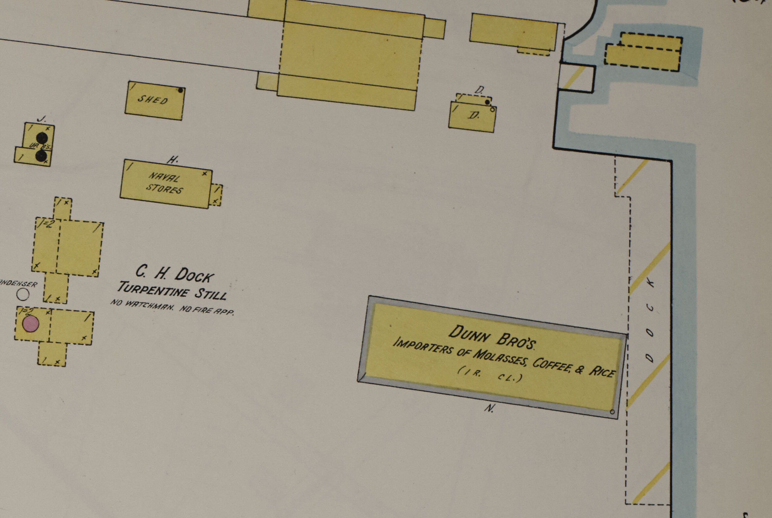
C. H. Dock Turpentine Distillery and Dunn Bros. Warehouse
A 1918 aviation photograph preserves one of the clearest surviving views of this industrial section of the Eagles Island waterfront.
The two-story C. H. Dock Turpentine Distillery stood beside and behind the much larger Dunn Bros. warehouse on the eastern shoreline of Eagles Island.
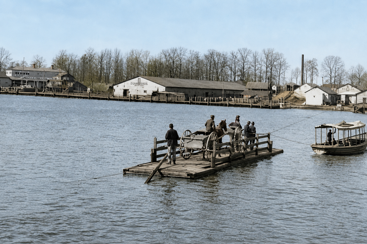
Dunn Bros. occupied a prominent waterfront warehouse identified by its large painted sign advertising molasses, coffee, and rice. The C. H. Dock operation was part of the naval stores industry that processed products derived from the region’s pine forests.
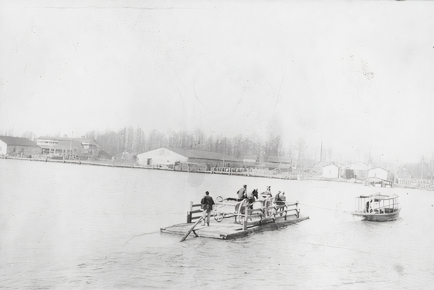
Although the C. H. Dock building is partly obscured in the 1913 panorama, its relationship to the Dunn Bros. warehouse can be seen much more clearly in a remarkable photograph taken in November 1918.
Historic Photograph and Digital Restoration
The two images below show the original museum photograph and a modern interpretive restoration. They are presented together so visitors can compare the historical evidence with the restored image.


About the Restoration
The image was restored and colorized using modern digital image-generation tools. The purpose was to make the historic scene easier to understand without intentionally changing the location or general form of its principal structures.
Color, contrast, tonal range, and apparent clarity were enhanced. The arrangement of the principal buildings—including the Dunn Bros. warehouse and the C. H. Dock Turpentine Distillery—remains based upon the original photograph.
Some small details, including textures, vegetation, boats, shoreline objects, lettering, and indistinct architectural features, may reflect digital interpretation where the original photograph did not contain enough visible information.
The original photograph remains the historical evidence. The restored image is presented as a visual interpretation rather than as a replacement for the original document.
The November 1918 Photograph
The museum catalog dates the photograph to November 1918 and describes it as showing a seaplane skimming the river with the Dunn Bros. building and other Eagles Island structures in the background.
An inscription associated with the photograph records that spectators lined the Wilmington side of the river to watch the airplane. What was photographed as an unusual aviation event has consequently preserved one of the best surviving views of this section of the Eagles Island waterfront.
A catalog reference also mentions the Market Street ferry slip and the ferryboat John Knox. The surviving description does not establish whether the photograph was taken aboard the ferry, from the ferry landing, or from another nearby vantage point. The exhibit therefore does not assign a more precise location to the photographer.
1915 Sanborn Fire Insurance Map

Historical Interpretation
Viewed together, the 1913 panorama, the 1915 Sanborn map, and the November 1918 photograph provide an unusually complete record of this part of the Eagles Island waterfront.
The large Dunn Bros. warehouse dominated the shoreline. Its waterfront location allowed imported and regional commodities to be received, stored, and shipped through the Port of Wilmington. The C. H. Dock Turpentine Distillery stood immediately beside and behind it, connecting this part of the waterfront to the region’s important naval stores trade.
The close concentration of warehouses, wharves, processing facilities, workboats, and transportation routes shows that Eagles Island was not an empty landscape across from Wilmington. It was a busy industrial district closely connected to the economic life of the city and the Cape Fear River.
What to Look For
In the 1918 photograph, find the large Dunn Bros. warehouse near the right side of the waterfront. Its painted commercial lettering makes it the easiest building to recognize.
Then look beside and behind it for the smaller two-story C. H. Dock Turpentine Distillery. The building is less visually prominent, but comparison with the Sanborn map confirms its identity and location.
Evidence
- Restored 1913 panoramic photograph of the Eagles Island waterfront
- 1915 Sanborn Fire Insurance Map
- November 1918 seaplane photograph in the Cape Fear Science and History Museum collection
- Museum catalog identification of the Dunn Bros. building and other Eagles Island structures
- Comparison of the buildings’ positions and relationships across the panorama, photograph, and Sanborn map
The identification of the Dunn Bros. warehouse and the C. H. Dock Turpentine Distillery is supported by the 1915 Sanborn Fire Insurance Map, the 1913 panorama, and the November 1918 museum photograph. The spatial relationship between the two buildings is consistent across these sources.